
")
NCKU teams up with US’s NCAR and NSPO to develop New Space Weather Monitoring and Forecasting System for the FormoSat-7
Whether on land, air, or sea, navigation systems rely on satellite guidance which are susceptible to interference. In order to assess the potential level of impact and disruption to satellite signals, global efforts towards developing a real-time space weather monitoring system have been in the works. Professor Charles Lin and Assistant Professor Chia-Hung Chen from National Cheng Kung University’s Department of Earth Sciences have been collaborating with the US National Center for Atmospheric Research (NCAR) and National Space Organization (NSPO) in fitting the soon-to-be-launched FormoSat-7 satellite with a new generation real-time space weather monitoring and forecasting system which is made possible by using the ionospheric data obtained from the FormoSat-3 satellite. The new monitoring and forecasting system will be able to predict deviations in GPS positioning and lower the error rate to effectively increase the accuracy of navigation systems on Earth. Future applications of this technology may include upgrading air navigation systems currently used around the world today to improve the efficiency and seamlessness of airplane take-offs and landings at airports.
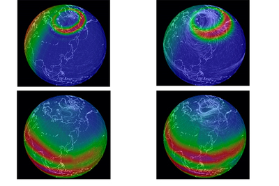
Professor Charles Lin underscored the space weather monitoring and forecasting system’s special capability – capturing changes in the density and distribution of plasma in the ionosphere between 100 to 1,000 kilometers above Earth’s surface. The ionosphere undergoes obvious changes within tens of minutes of being exposed to a solar storm. Such an event causes interference in high frequency wireless communications utilized by nautical vessels, aircraft, and emergency rescue operators. The solar storms in the ionosphere may also severely weaken, or even block, satellite signals, resulting in skewed GPS routes. Such deviations in GPS positioning range from 10 to 100 meters. For example, as a result of the affected satellite signals, your GPS will erroneously tell you that you’re driving on the Wugu-Yangmei Elevated Expressway when you’re actually driving on the Sun Yat-sen Freeway.
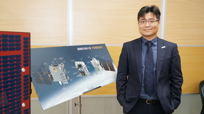
At a press conference held on October 16th by the Taiwan’s National Applied Research Laboratories (NARLabs), Professor Lin was invited to share the results of the collaboration between NCKU, NCAR, and NSPO on developing the space weather monitoring and forecasting system. NARLabs Vice President Kuang-Chong Wu mentioned in his speech that the FormoSat-7 is an extension of the FormoSat-3 project, highlighting the fact that combining data acquired from the FormoSat-3 satellite with space weather forecasting models allows for a holistic representation of the disruptive effects of solar storms on the ionosphere in addition to three-hour forecasts of shifts in ionospheric density.
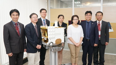
The FormoSat-3 satellite has been in orbit for 12 years to date and is the primary supplier of ionospheric data, accounting for around 4.5 million records of data out of the global total of 5 million records which were obtained by remote occultation techniques. Currently, new ionospheric data takes two days to acquire. The FormoSat-7 satellite, however, will take around 97 minutes to orbit the Earth and can provide ionospheric data every 30 minutes. The FormoSat-7 satellite is estimated to supply a wide array of data at an amount three to four times than the current rate. The satellite, which was jointly developed by Taiwan and the US, will primarily provide mid- to low latitudinal space observations given that most ionospheric plasma is distributed in the mid- to low latitudes where Taiwan is also situated.
According to Professor Lin, NCKU began its research into real-time space weather monitoring and forecasting in 2014 and developed a prototype system in 2017. Moreover, the team at NCKU established a new system for the FormoSat-7 which will be able to go into operation immediately after launch. With the aim of perfecting the real-time monitoring and forecasting system and optimizing the accuracy of observational results, the research team not only leveraged data acquired from the FormoSat-7 but also developed a physical model to compensate for insufficiencies in the data. In addition, data assimilation techniques were used to correct disparities between satellite observations and physical model data. This monitoring and forecasting system has been used to analyze solar storms, including providing a holistic representation of the solar storm as well as the ionospheric changes and the impacts thereof on the Earth and GPS positioning in March 2015. TheSpace Weather Operational Office (SWOO) in Taiwan’s Central Weather Bureau (CWB) will be the home of the new system which will receive direct data feeds of ionospheric data from the FormoSat-7. The CWB will then disclose the data as well asthe space weather forecast product on its website for civilianapplications.
Historical data shows that a solar flare event in 2017 had completely shut down the high frequency radio communications in Puerto Rico which adversely affected hurricane relief efforts that were in progress at the time and cut off radio communication with an aircraft flying in the area. In November 2015, a solar radio burst forced a Swedish airport to close down for several hours. In September 2011, a solar storm rendered the GNSS aviation guidance temporarily ineffective in the eastern region of North America, which caused a perpendicularity error of over 100 meters.
Professor Lin further mentioned that solar storms and solar radio bursts are still challenges for the real-time monitoring and forecasting system, never mind insufficiencies in space observation data. In regards to the more familiar type of reporting – weather reports, the accuracyof weather forecasts has been improved in recent years. This is because there is a sufficient amount of observational data for making forecasts. Currently, meteorological models receive more than 4 million records of meteorological data in every 6-hours interval in contrast to the less than 50,000 records of space observation data per day. After the FormoSat-7 is launched, it is expected to significantly raise the amount of data for space observations as well as increase the feasibility of space weather monitoring and forecasting.
Professor Charles Lin underscored the space weather monitoring and forecasting system’s special capability – capturing changes in the density and distribution of plasma in the ionosphere between 100 to 1,000 kilometers above Earth’s surface. The ionosphere undergoes obvious changes within tens of minutes of being exposed to a solar storm. Such an event causes interference in high frequency wireless communications utilized by nautical vessels, aircraft, and emergency rescue operators. The solar storms in the ionosphere may also severely weaken, or even block, satellite signals, resulting in skewed GPS routes. Such deviations in GPS positioning range from 10 to 100 meters. For example, as a result of the affected satellite signals, your GPS will erroneously tell you that you’re driving on the Wugu-Yangmei Elevated Expressway when you’re actually driving on the Sun Yat-sen Freeway.
At a press conference held on October 16th by the Taiwan’s National Applied Research Laboratories (NARLabs), Professor Lin was invited to share the results of the collaboration between NCKU, NCAR, and NSPO on developing the space weather monitoring and forecasting system. NARLabs Vice President Kuang-Chong Wu mentioned in his speech that the FormoSat-7 is an extension of the FormoSat-3 project, highlighting the fact that combining data acquired from the FormoSat-3 satellite with space weather forecasting models allows for a holistic representation of the disruptive effects of solar storms on the ionosphere in addition to three-hour forecasts of shifts in ionospheric density.
The FormoSat-3 satellite has been in orbit for 12 years to date and is the primary supplier of ionospheric data, accounting for around 4.5 million records of data out of the global total of 5 million records which were obtained by remote occultation techniques. Currently, new ionospheric data takes two days to acquire. The FormoSat-7 satellite, however, will take around 97 minutes to orbit the Earth and can provide ionospheric data every 30 minutes. The FormoSat-7 satellite is estimated to supply a wide array of data at an amount three to four times than the current rate. The satellite, which was jointly developed by Taiwan and the US, will primarily provide mid- to low latitudinal space observations given that most ionospheric plasma is distributed in the mid- to low latitudes where Taiwan is also situated.
According to Professor Lin, NCKU began its research into real-time space weather monitoring and forecasting in 2014 and developed a prototype system in 2017. Moreover, the team at NCKU established a new system for the FormoSat-7 which will be able to go into operation immediately after launch. With the aim of perfecting the real-time monitoring and forecasting system and optimizing the accuracy of observational results, the research team not only leveraged data acquired from the FormoSat-7 but also developed a physical model to compensate for insufficiencies in the data. In addition, data assimilation techniques were used to correct disparities between satellite observations and physical model data. This monitoring and forecasting system has been used to analyze solar storms, including providing a holistic representation of the solar storm as well as the ionospheric changes and the impacts thereof on the Earth and GPS positioning in March 2015. TheSpace Weather Operational Office (SWOO) in Taiwan’s Central Weather Bureau (CWB) will be the home of the new system which will receive direct data feeds of ionospheric data from the FormoSat-7. The CWB will then disclose the data as well asthe space weather forecast product on its website for civilianapplications.
Historical data shows that a solar flare event in 2017 had completely shut down the high frequency radio communications in Puerto Rico which adversely affected hurricane relief efforts that were in progress at the time and cut off radio communication with an aircraft flying in the area. In November 2015, a solar radio burst forced a Swedish airport to close down for several hours. In September 2011, a solar storm rendered the GNSS aviation guidance temporarily ineffective in the eastern region of North America, which caused a perpendicularity error of over 100 meters.
Professor Lin further mentioned that solar storms and solar radio bursts are still challenges for the real-time monitoring and forecasting system, never mind insufficiencies in space observation data. In regards to the more familiar type of reporting – weather reports, the accuracyof weather forecasts has been improved in recent years. This is because there is a sufficient amount of observational data for making forecasts. Currently, meteorological models receive more than 4 million records of meteorological data in every 6-hours interval in contrast to the less than 50,000 records of space observation data per day. After the FormoSat-7 is launched, it is expected to significantly raise the amount of data for space observations as well as increase the feasibility of space weather monitoring and forecasting.
Provider:
New Center
Date:
2018-10-22
