
")
Mystery solved! Space plasma simulation helps explain the puzzling underestimation of airglow heights by FORMOSAT-2 scientific payload
Written by and image credit to NCKU Institute of Space and Plasma Sciences.
With the launch of the third phase of the “National Space Technology Long-Term Development Program” in 2019, Taiwan has planned to invest NT$25.1 billion in 10 years to develop cutting-edge space missions and to establish its own space industry. While technological development appears to be the path to these goals, pursuit of advancement solely from the perspective of engineering may not be the best approach. That is because technologies are built on a foundation of theories. Sometimes, theories and theory-based simulations are necessary for breakthroughs in technology. This concept has recently been demonstrated by a research team from the Institute of Space and Plasma Sciences (ISAPS) of National Cheng Kung University. The team has solved a decade-long mystery of underestimation of airglow altitudes in images obtained by remote-sensing satellite, and provided an analytical solution to recover the correct airglow spatial distribution. The study is published in the October 2021 issue of Journal of Geophysical Research: Space Physics.
A team from the Institute of Space and Plasma Sciences (ISAPS) of NCKU analyzed data obtained by remote-sensing satellite
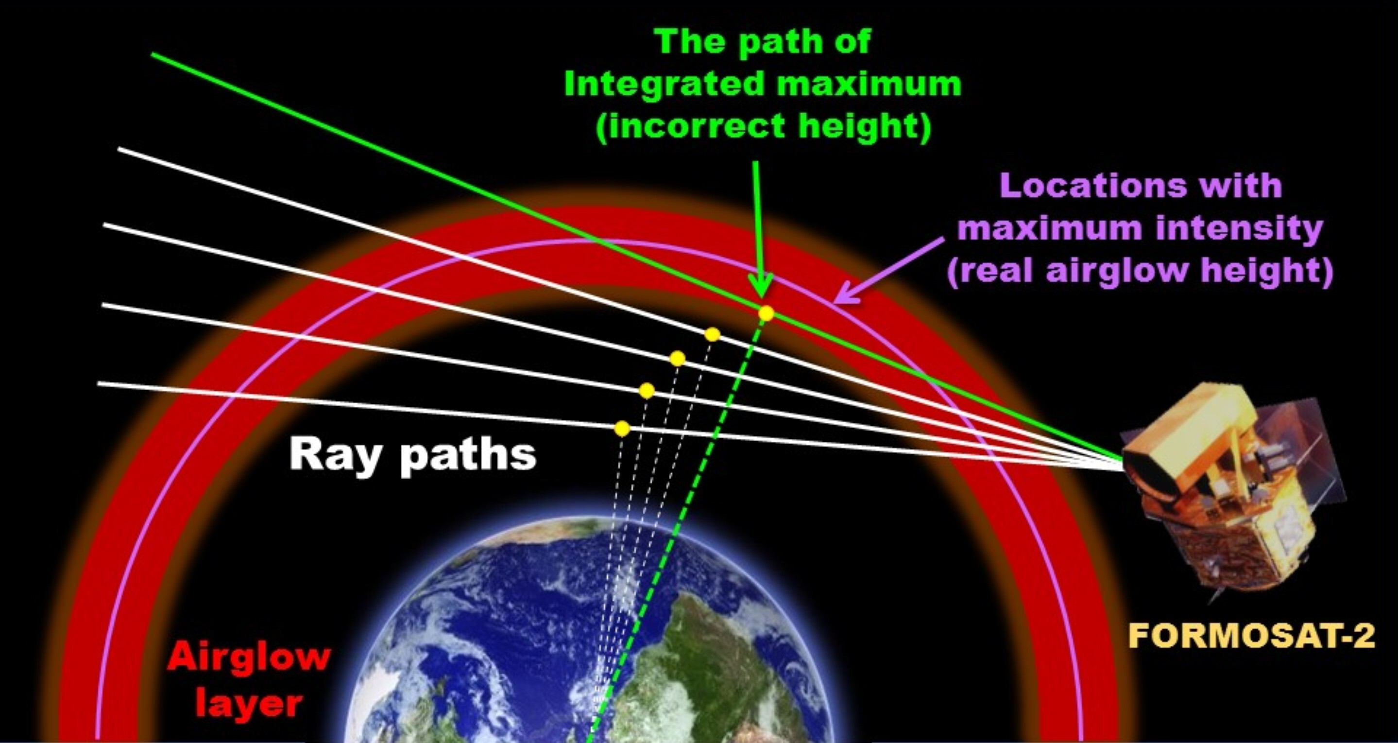
What motivated the study was the nighttime airglow observations by ISUAL, an acronym for the scientific payload Imager of Sprites and Upper Atmospheric Lightning aboard the FORMOSAT-2 spacecraft, which was launched in 2004. After ISUAL began its long-term observations in the upper atmosphere and the ionosphere in 2006, researchers realized that the airglow layer in the images obtained by the side-viewing payload was constantly lower in altitude by about 20 km than commonly recognized. For the airglow layer that has a vertical range of only about 50 km, a shift by 20 km is significant, as the total altitude misinterpreted for the presence or absence of airglows would be almost the size of the airglow layer itself. Despite repeated efforts by the ISUAL team to reexamine the data and the formulas behind the observations, there was no explanation for the discrepancy. The issue was then put aside.
The mystery was examined two years ago by the ISAPS team, comprised of Professor Sunny Wing-Yee Tam, Assistant Professor Tzu-Fang Chang, postdoctoral researcher Chih-Yu Chiang, and graduate student Ke-Chen Huang. The team built a three-dimensional grid of airglow intensity based on space-plasma and neutral-particle models and the mechanism of plasma chemical reactions. They then used simulations to reconstruct an event of ISUAL observations, integrating the airglow intensity along each ray path to find its radiance. By following the practice of ISUAL to project the radiance of a ray path to its tangent point, the ISAPS team found that they produced an image with the maximum radiance located at about 20 km below the height of the maximum airglow intensity. The reason for the difference in altitude is due to the fact that the tangent point corresponds to the lowest altitude along a ray path, while significant contribution to the radiance may come from somewhere else on the ray path.
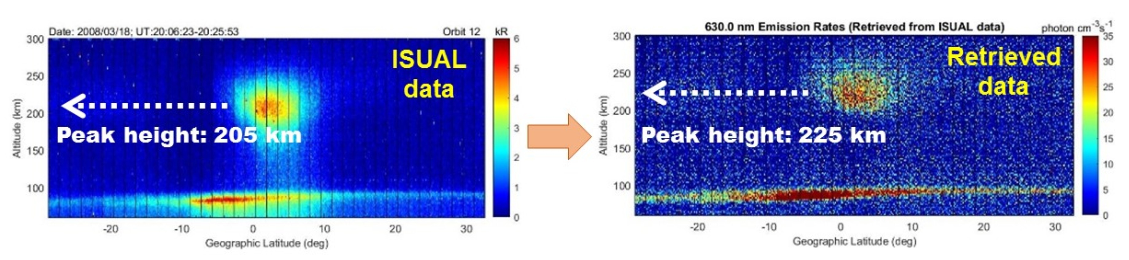
With the mystery of the discrepancy in height solved, the ISAPS team aimed to remedy the problem. By considering the geometry of the observations and utilizing symmetry as a reasonable approximation, the team derived an analytical formula for the inversion, retrieving airglow intensity profiles from an array of radiance. Application of the formula to the simulated observation event was able to recover the original airglow locations. With the proven success, the formula was then applied to the ISUAL data, resulting in airglow locations that turned out to be about 20 km above the altitude indicated by the data. The disagreement between ISUAL observations and previous studies has been resolved.
The team produced an image with the maximum radiance located at about 20 km below the height of the maximum airglow intensity
The study by the ISAPS team is not only relevant to the ISUAL images; the retrieval method can be applied to all data associated with side-viewing payloads similar to ISUAL to recover the correct airglow profiles. Future satellites can even incorporate the method into their data-generating algorithm to prevent data misrepresentation.
“It is essential that satellite data be correct. Otherwise, they will lead to erroneous analyses and interpretations, which may play a role in the planning of the space program,” said Tam, who leads the ISAPS study. Chang, a member of the research team with expertise in satellite instrumentation, also emphasizes the importance of the correctness of data, “One has to be careful with every aspect regarding satellite data. If the data cannot be correctly interpreted, the meaning of instrument design and development will be lost.” The ISAPS team believes that to correct the misleading ISUAL data is a foremost task.
The FORMOSAT-2 mission officially ended in 2016. The ISUAL payload has stopped generating new data since then. Usage of the ISUAL data has also decreased sharply. However, with the analytical formula provided by the ISAPS team’s study, researchers can quickly and easily retrieve the correct airglow altitudes by themselves. Hopefully, that would rekindle the interest of the space science community in the ISUAL data and, in turn, substantially increase the visibility of Taiwanese satellites.
Further information:
Retrieval of Airglow Emission Rates in Analytical Form for Limb-Viewing Satellite Observations at Low Latitudes, published in the October 2021 issue of Journal of Geophysical Research: Space Physics.
Authors: Sunny W. Y. Tam, Chih-Yu Chiang, Ke-Chen Huang, and Tzu-Fang Chang
Retrieval of Airglow Emission Rates in Analytical Form for Limb-Viewing Satellite Observations at Low Latitudes, published in the October 2021 issue of Journal of Geophysical Research: Space Physics.
Authors: Sunny W. Y. Tam, Chih-Yu Chiang, Ke-Chen Huang, and Tzu-Fang Chang
Supporting Information for “Retrieval of Airglow Emission Rates in Analytical Form for Limb-Viewing Satellite Observations at Low Latitudes”
Authors: Sunny W. Y. Tam, Chih-Yu Chiang, Ke-Chen Huang, and Tzu-Fang Chang
Provider:
News Center
Date:
2021-12-22
